QUEBEC
Montreal
NO PART OF THE FOLLOWING
ARTICLE AND PHOTOGRAPHS
MAY BE REPRODUCED WITHOUT
PERMISSION FROM THE AUTHOR ©
This amusement area opened June 2, 1906. It was located on just over 6 hectares of property on Rue Notre Dame East (street), with its back to The St. Lawrence River. It had broad walkways with many trees & benches and a central park area. The focal point of Dominion was a tall tower with a beacon on top. It sat near the corner of the main `L' shaped boardwalk, of which one side ran along, but faced away from, the park's main-entrance street. The connecting boardwalk ran along the north side of a "Shoot-the-Chutes" water ride. Around this ride was smaller, partly curved, boardwalk. This layout, along with the tower, would be copied to a great extent by Scarboro Beach Park when it opened in 1907. Both parks had the same owners (Harry and Mabel Dorsey) and likely the same designer(s) and/or builder(s).
|
Dominion Park Aerial View circa 1910s 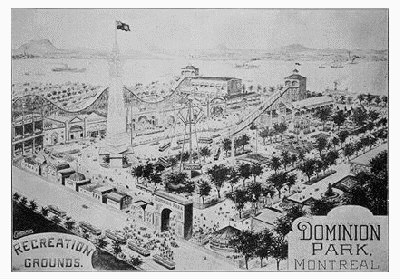 At far Center Left is the two-story Scenic Railway station. The ride's undulating track may be seen in the background, but its height and drop angles are exaggerated in this drawing. The park tower stands at the foot of the Chutes run-out pond, and on this side of the pond is The Aerial Swings ride. Close to that is the tree-lined, central grove area. Beyond the park runs The St. Lawrence River, while the street where the trams are unloading people (Center Bottom) is Notre Dame East. Note the carousel to the right of the entrance gate. Compare this pictorial with the 1914 map near the end of this article to garner an idea of some of the changes in nine seasons. |
|
Dominion Park Entrance Likely 1906 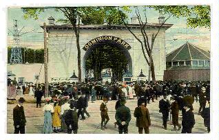
|
A hand-tinted postcard depicts the park entrance on Rue Notre Dame East. It was likely taken within a year or two of the park's opening. Visible behind the fence to the right of the gate is the carousel building, and to the left is the park's Aerial Swings ride. General admission was 10 cents; 5 cents for children. Attractions were extra charge. |
| Here is a later image. Contrast the horse-drawn carriage with its replacement: the horseless carriage. |
Dominion Park Entrance Late 19-0s or Early 1910s 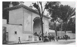
|
THE BOARDWALKS
The park was surrounded on three sides by boardwalks,
along which were many attractions. Central to these were
a tall tower, a "Shoot-the-Chutes" ride and a tree-filled
grove. Interspersed within the latter were additional attractions.
The first, third and fourth images were
taken from the upperChutes platform
and show the boardwalk area on three sides.
|
South and West Boardwalks Circa 1906 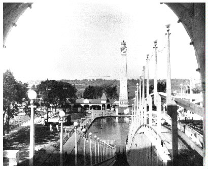 This shows the drop of the Chutes ride. The crest of the lift hill may just be seen at Lower Right below the railing. Lights surround the opening through which each boat begins its plunge; these are seen at Upper Left and Upper Right . On the opposite side of the run-out pond is the park tower in front of the West Boardwalk. Notice the curved boardwalk surrounding the pond running from Center to Lower left. |
|
West Boardwalk Circa 19-0s 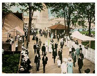 The picket fence at the right surrounds the Aerial Swings, out of frame to the right. This may be seen in photographs farther on. |
The West Boardwalk is seen here from a lower angle. In the background is the North Boardwalk, with the junction of the two being occupied by the station for The Scenic Railway. It is the angled building with the pillars just left of Center Top. To its right closer to the foreground is the base of the park's tower. At Center Right & up is the Chutes run-out pond. Above it, partially hidden by foreground trees, the tall pillars belong to Ye Olde Mill. |
| Starting with the first portal on the right are The Crystal Maze, Myth City, Ye Olde Mill, The Laundry, a Laughing Gallery, and at the corner, the angled building is The Scenic Railway station. Some of the coaster structure may be seen behind the buildings at the right. The building to the left of the coaster station is some sort of studio. |
North Boardwalk
Circa 1906 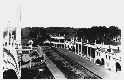 Although very faint in this photo, note the miniature railway tracks running between the two wooden boardwalks. |
|
This view is to the right of the above
and is later in time. Visible, right
to left from the large portal at the
right, are entrances to "Bump the Bumps",
Tours of the World, an unknown
attraction, The Crystal Maze,
Myth City, and Ye Olde Mill.
More of the roller coaster is visible above
& behind these buildings.
Note the miniature railway tracks at Lower Left. |
North Boardwalk Circa 1910 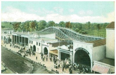 Under the awning at Lower Right are food concessions. |
|
North Boardwalk Circa 19-0s 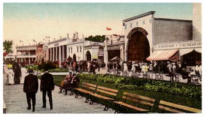 |
Here's a ground-level view looking west along the North Boardwalk. |
|
From Center Left, the buildings are an unknown
studio (with the red roof) and the angled
building at the corner is the entrance to the
roller coaster. Next is The Laughing Gallery,
The Laundry, Ye Olde Mill,
Myth City, The Crystal Maze,
an unknown attraction, Tours of the World
and Bump the Bumps. The next buildings are
concessions. The one at the right is selling
ice cream. At one point, N.X. (Nathan) Nathanson managed these and the ones at Scarboro Beach Park. He would later become a movie theater mogul in Canada. |
|
This is taken in the opposite direction from the above
and thus, looks East. In the right background is The
Shoot-the-Chutes. To its left across the boardwalk is the pillared entrance to Ye Olde Mill. |
North Boardwalk Circa 19-0s 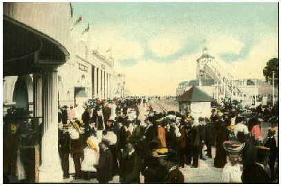 The pillars in foreground are the entrance to The Scenic Railway. Receding into the center background are the miniature train tracks. |
Here are some closer views of
several of the park's attractions.
|
A woman takes the final plunge to exit
the funhouse. The sign above the bars
reads: "We Feed the Animals at 6 P.M."
|
House of Nonsense
circa 19-0s 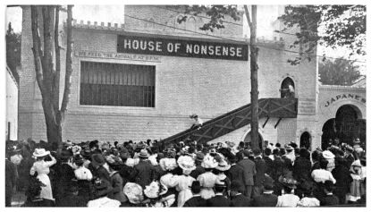 The building at the right has a sign with the word "Japanese". This may have been Japanese Roll-Downs, a game in amusement parks of the era. This funhouse would be destroyed in the 1913 fire. |
|
House of Nonsense circa 19-0s 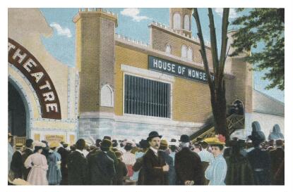
|
| A hand-tinted postcard shows the the park's funhouse. The theater at the left may be the one that came to house "Shipwreck of the Titanic" |
|
Here is a close-up of the entrance to Ye
Olde Mill. Barely visible in this photo,
is a painted backdrop - a hint of the scenes
to be viewed during the ride.
|
Ye Olde Mill
circa 19-0s 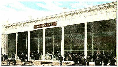
|
|
Myth City
circa 19-0s 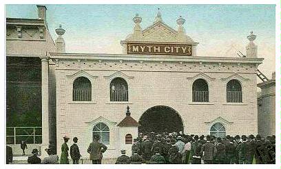
|
A large crowd lines up at the entrance to Myth City. The building to the left is Ye Olde Mill, while to the right is The Crystal Maze. Note the workman's ladder on its roof bridging the gap to the roof of Myth City. |
|
Crowds mingle in front of this unknown attraction.
The ticket booth's sign advertises "Admission 10c".
|
An Unknown Attraction
circa 19-0s 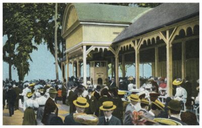
|
Another attraction was an undulating slide called "Bump the Bumps". As seen in other pictures, the "Bumps" building does not have the sign in earlier photographs, so the slides were either not there until later, or it did not have the large sign ringing the top of its portal entrance in earlier years.
Then there was The "Laundry", but it's not known what it featured. Its entrance may be seen in the postcard below, along with the park's 16-passenger miniature railway,
|
A miniature train moves along beside the
North Boardwalk on a warm day as patrons relax
on the benches. This ride ran around the
perimeter of the Chutes and its pond.
Seen in the background are The Laundry
and Ye Olde Mill. Note the light
standards lining the boardwalk and their
curved iron fixture supports.
|
Miniature Railway
circa 1910 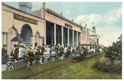 Landscaping has been done by this season, with grass on either side of the train tracks. Flowers and bushes are seen at the right. |
A "Tickler" ride was in the park. This had a pinball-like layout in which a circular car rolled down a zig-zag incline, revolving while bouncing off guide rails as it careened down the course. Later on, the park received a Mangels "Whip" and a ferris wheel.
|
Tickler
circa 1910s 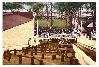
|
| Here is the ride as seen from the start of the run. The curved guide rails are clearly seen. Note the return track at the right that brought cars back to the top. |
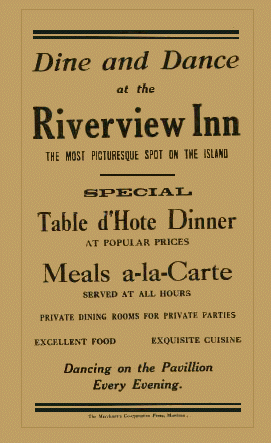
Further attractions included the already-mentioned carousel,
a large restaurant (possibly the Riverview Inn?), a dance
pavilion (connected with the restaurant?), and "The Johnstown
Flood". This may have been a live-action re-enactment. More
likely though, it was a representation of the flood through
miniatures, because other Canadian parks had similar attractions
in miniature at the time. A photo of its entrance may be seen in
Canada's Amusement Park Beginnings
along with a later shot of Dominion Park's "Whip" and ferris wheel.
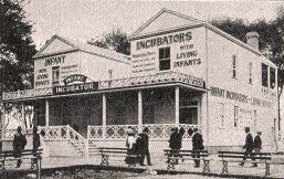
![]() An odd attraction by today's amusement park standards was The
"Infant Incubators". This featured live babies in enclosures
tended by nurses. A similar attraction was featured at a number of
exhibitions and amusement parks in Canada during the first two or
three decades of the 20th century. This attraction only lasted a
few seasons as it was reported closed in 1909, so it closed that
year or perhaps at the end of the 1908 season.
An odd attraction by today's amusement park standards was The
"Infant Incubators". This featured live babies in enclosures
tended by nurses. A similar attraction was featured at a number of
exhibitions and amusement parks in Canada during the first two or
three decades of the 20th century. This attraction only lasted a
few seasons as it was reported closed in 1909, so it closed that
year or perhaps at the end of the 1908 season.
A new ride opened for the 1907 season called "Mystic Rill". This was a wet dark-ride where small, three-bench boats just over three metres long wound around an enclosed water course. Often these types of rides had the patrons pass by illuminated scenes or be part of gags in the dark. These might include hair hanging down to touch the riders or actors unexpectedly jumping out. Dominion's version included at least rock formations and a painted dragon, but it's unknown if there were any gags or live-action cast. The more likely is that this was a "Tunnel of Love" style ride where patrons could cuddle together for a few minutes.
This ride's layout ran mostly between the front of The "Scenic Railway" and the backs of many of the attractions on the North Boardwalk. Perhaps its entrance may have been the "unknown attraction" mentioned in some previous photo descriptions.
|
Boat Blueprint for the Mystic Rill 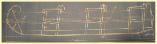 The boats were open topped and sat six people. |
|
Location Blueprint for the Mystic Rill 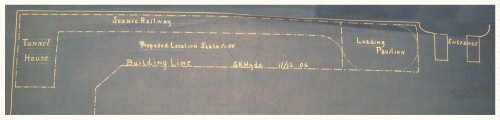 This blueprint appears to be for Scarboro Beach Park because the park entrance and Scenic Railway's station (shown above as "Loading Pavilion") were in the positions shown here. Since both parks had the same owners and likely the same designers, it would not be unusual that the blueprint from one park would be used in the other despite some differences in layout. Regardless, Mystic Rill was to be located between the coaster and the backs of other attractions. Note at left, the "Tunnel House" for the Scarboro coaster. This is described in the "Scarboro" article as the "Cavern". |
Some of the attractions mentioned in the second and third last paragraphs may have been installed after a fire in 1913. It broke out Saturday, June 28 in an attraction that featured the horse act "Mazetta". Apparently the horse kicked or knocked over a gasoline-fed light or torch and the spilled fuel spread the flames quickly. Park fire fighters tried to fight the flames but were hampered by inadequate water pressure. As the flames spread, electricity was turned off to avoid shock as the wires fell. When it was realised that they were under-equipped to handle the growing size of the fire, Montreal fire fighters were called in from 10 kilometres away to assist. As well, a government tug boat, "Saint-Pierre", facilitated by using its powerful pumps to boost water pressure.
Fires attract people, and in this case, the number of spectators had grown so great from park patrons and by the curious arriving from the neighbouring community, that the park manager requested police assistance. This saw a 50-strong force arrive to enforce order.
The fire was brought under control in an hour and a half. It had burned from around 9 PM till approximately 10:30 PM. Damages were limited to between $15,000 and $20,000, but lost were The "House of Nonsense" funhouse, "Shipwreck of the Titanic" and the "Mazetta" building. All were located between the carousel and the "Wild West" exhibition grounds on the south side of the park. Fortunately, there were no deaths, and minor injuries were related to crowd control, not the fire itself. All animals from the "Wild West" and "Mazetta" attractions were led away safely.
Within a day or so of the site cooling, a team of demolition men levelled the ruins. The park rebuilt and it was reported that the horse show was restored. The "Titanic" exhibit was replaced but nothing has surfaced as to what the new show was, nor as to whether the funhouse was rebuilt or replaced with a different attraction.
The
ROLLER COASTERS
Two roller coasters ran during the park's life. The first was "Scenic Railway". Its layout was located behind all the attractions on the North Boardwalk and may have included a tunnelled section. This ride ran five-bench cars in trains of two and included a brakeman. It was installed in 1906, and apparently built under contract from T.M. Harton. Most sources credit the designers as J. A. Griffiths and George Crane. However, recent evidence in the form of a series of blueprints has surfaced that shows the name: "L.A. Thompson Scenic Ry Co". This implies that La Marcus Thompson was the designer, or at least someone from his company. Now, given that all these people were intertwined in various ways and within one another's companies, and that Griffiths and Thompson had collaborated on the first "Scenic Railway" in the late 1880s, it's possible that all were involved with the Dominion Park coaster. On the other hand, by the 1900s, Thompson and Griffiths had separated and developed competing companies, so the `Thompson' name on the blueprint should be given more weight regarding the designer credit.
|
Scenic Railway Blueprint Name Detail 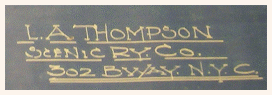
|
|
Partial Blueprint for the Scenic Railway 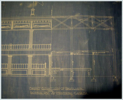
|
|
Blueprint for the Scenic Railway Station and Included Track 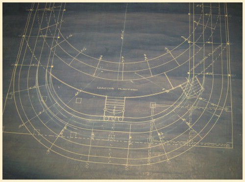
The track at the bottom ran outside the station at the second level. It is behind the railing above the entrance seen in photos farther on. The entrance led under this track to a stairway which ended on a raised loading platform. Its stairs are seen in the diagram. The other stairway on the right leads to the exit. |
|
Scenic Railway Car Blueprint - Front 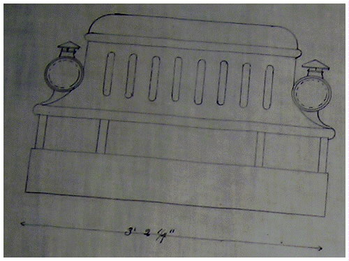
|
|
Scenic Railway Car Blueprint - Side 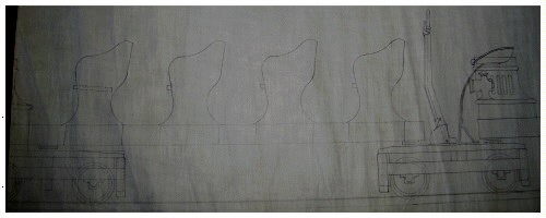 At the right is the lever and ratchet mechanism for the brakeman. There were no in-track brakes. Notice that each car truck is independent. This allows the long cars to negotiate tight turns because one truck can pivot for a turn while the other remains straight until it reaches the turn. |
This coaster likely lasted until 1919. There was a fire that year which killed a number of people on an adjacent ride and burned a section of The "Scenic Railway" which then collapsed. Evidence it was lost is that Fred Church built a "Dips" coaster here in 1920. That ride lasted until 1929. Another clue is the following account:
|
Lynda McCormick volunteered that her father knew of the Dominion Park fire. He was about 14 at the time and recalled it well. The fire took place the same year his mother died of influenza (which at that time was a world-wide pandemic, killing millions), so that time period was ingrained in his memory. According to his account, the fire started at the coaster, and he believes that the people who died were those that were trapped on it. He says the coaster was destroyed by the fire. Mr. McCormick also remembered it vividly for another reason: Two of his older brothers and one of his sisters were at the park the day of the fire and had ridden the roller coaster. "You can only imagine how they all felt since they could have been the ones trapped on the ride", says Lynda. Research into this fire, shows that Lynda McCormick's father was apparently misinformed. According to the Monday, August 11th edition of the Montreal Gazette, the fire started in the "Mystic Rill" dark ride on the previous afternoon. It caught seven people within the ride due to the lack of emergency lighting and exits, as modern versions would have. All those trapped died. Later, an eighth body and the remains of a dog were also found. It's not known if "Mystic Rill" was replaced with a similar ride or not. (Note that another source gives June 28, 1919 as the date of this tragedy, but this must be confused with the date of the 1913 fire.) |
|
Scenic Railway
circa 19-0s 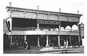
|
This shows the two-story coaster station.
No exterior ticket booth can be seen here,
so this is likely earlier in time than the
next two photos. At the left is an unknown studio. Note the miniature train tracks in the foreground. |
|
A closer view of the entrance. Notice that the ticket booth at the Center Bottom differs from the type and location of the one in the photo below. Also, the exit staircase inside the structure at Lower Right was constructed sideways from the blueprint representation seen father back. |
Scenic Railway
circa 19-0s 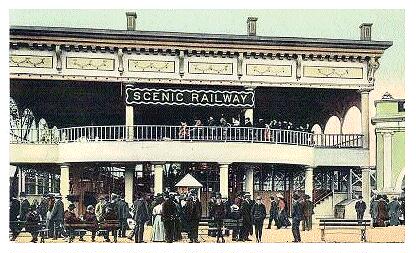
|
|
Scenic Railway
circa 19-0s 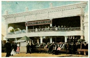 |
From another angle, is a hand-tinted view of the entrance to the coaster. A trainload of people may be seen on its second level. |
The
SHOOT-the-CHUTES
|
Shown in this closer view are the building and ramps as seen from the opposite side of the midway from the views above. A boat has just gone down the ramp and has begun its skim across the run-out pond. Note the extra Chutes boats in the foreground and the ticket booth, center left. |
The
Chutes
circa 19-0s 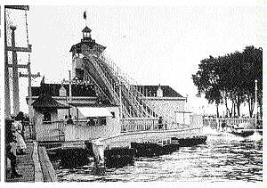
|
 The Chutes and Boardwalk circa 19-0s |
This is a wider, and slightly different angle view of the above. Multitudes of park benches line the boardwalk. The miniature railway tracks are at the left. |
|
Shoot-the-Chutes
circa 19-0s 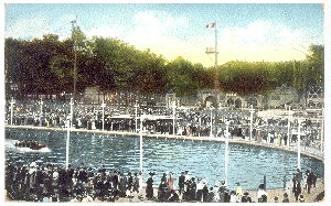
|
A view to the right of the above two shots, but
taken at a different time. It shows the end of
the Chutes pond with spectators looking
at a boat moving across the pond. Note the tower across the pond. It appears to have a diving platform near the top. |
|
The
Chutes Run-Out Pond circa 19-0s 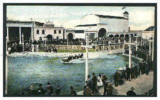
|
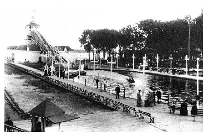
The run-out pond is seen from the curved,
South Boardwalk. Across the water to the
far left is a portion of The Ye Olde
Mill dark ride. To its right is
Myth City and next to it is The
Crystal Maze. The largest portal
to the right is the entrance to what is,
or would later become, a Bump the
Bumps ride. Beyond that, the
curved-roof building is unknown, but
may have been the dance pavilion or an
exhibition hall.
|
| Just discernable to the left of the Myth City sign on top of its building, is part of the roller coaster track and railing. |
| Here is another view of that unknown building, again as seen from across the pond. Note that this building is not represented on the 1914 map, seen farther on, so it may have been lost in the 1913 fire. |
Shoot-the-Chutes
circa 19-0s 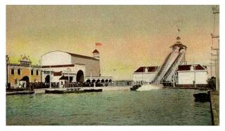
|
| Here is a unique view from the Tower at the end of the run-put pond. The St. Lawrence River flows in the background. |
Shoot-the-Chutes
circa 1910s 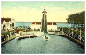
|
|
Shoot-the-Chutes
circa 19-0s 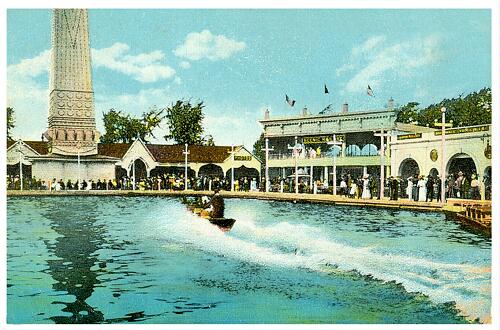
This wonderful hand-tinted postcard shows crowds surrounding the Chutes run-out pond while a boat skims across it. In the left background is the park's tower. This view shows some of the patterns outlined in lights on it. Across the way are the buildings of the West (at left) and North (at right) boardwalks. |
|
Blueprint for a Shoot-the-Chutes Boat Bottom Shoe 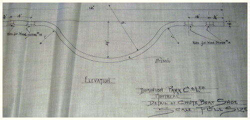
|
The
CENTRAL AREA
 As was seen in the opening illustration, Dominion Park had a
large common area in its center to one side of The "Shoot the
Chutes" ride. Mainly a picnic/relaxation area, it came to have
some amusements placed there in later years. However, right from
the start there was a performance stage located on the North side
and also a bandstand. Later, other stages were placed nearer the
"Chutes" pond and in the grove.
As was seen in the opening illustration, Dominion Park had a
large common area in its center to one side of The "Shoot the
Chutes" ride. Mainly a picnic/relaxation area, it came to have
some amusements placed there in later years. However, right from
the start there was a performance stage located on the North side
and also a bandstand. Later, other stages were placed nearer the
"Chutes" pond and in the grove.
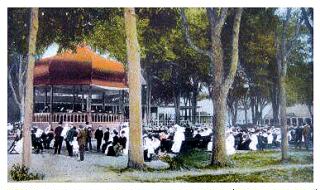
At one point Henri Delcellier conducted the Dominion Park
concert band. This was likely the house band for the park, but
Dominion also featured many outside acts on the bandstand over
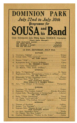
the years. The handbill shown here at the left advertises John
Sousa, a popular American marching band leader and composer. The
year is not known but given the seasons the park ran and that Sousa
died in 1932, the only possible years where July 22nd fell on a
Saturday were 1911, 1916 and 1922.
The park brought in cowboy acts to perform for its patrons. One of these was Weadick's Wild West Show. It was touring Canada and one stop was in Montreal at Dominion Park. The star of the show was silent film cowboy Tom Mix. He had just started in the motion picture business a couple of years earlier but was off for part of the 1912 season so he signed on to be in the Wild West show. (His true film stardom would not occur until the late 1910s and the 1920s.) Tom's performance in the spring of 1912 saw him taken to hospital from two injuries received at Dominion.
First, he was stabbed in the jaw by the horn of a steer during a bulldogging event. Despite being knocked unconscious and the damage to his jaw, he was patched up so he could participate in the bucking bronco event. Probably not quite up to the task after his injury, Tom was thrown from the horse and knocked out again. This time, he was taken to hospital in a horse-drawn ambulance against his protests of leaving the show before its conclusion. (Motor vehicles were rare in those days - even in Montreal.) He recovered and went on to Calgary and Illinois for some more shows before returning to do one more series of performances at Dominion Park. These ended in July, after which he returned to his ranch in Dewey, Oklahoma to see his new daughter, Ruth. She had been born July 13, 1912, three days before Tom returned.
There also may have been diving and swimming shows. One photo farther back shows what may be a diving platform near the edge of the "Chutes" pond. (This pond was referred to as the "Lagoon" in postcard photos, by the way.)
One other attraction of note was the Jack Delaney - Larry Gaines boxing match held on January 22, 1928 at Dominion Park. The match saw Canadian fighter Delaney as victor after 15 rounds. (Note that the date of February 2nd is also given for this fight.)
|
Given the minimal vegetation, this shot
was likely taken during the opening season,
1906. The performance stage may be seen at
the right. Buildings in the background from
left to right are The Scenic Railway,
The Laughing Gallery, The Laundry,
Ye Olde Mill, Myth City, and The
Crystal Maze.
|
The Performance Stage
Likely 1906 
|
|
Crowds
Circa 1910 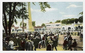
|
Crowds mill around the central area. The park's tower may be seen at Center Left. Behind are the West (at left) and North (at right) Boardwalks. |
|
Crowds here throng the West Boardwalk. At the
right is the tower for the Aerial Swings,
surrounded by a pocket fence. The North Boardwalk
buildings may be seen in the background. The park's entrance is out of frame behind and to the left of the photographer taking this photo. |
Crowds
Circa 19-0s 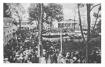
|
A popular ride at the time was The "Aerial Swings". This was a
Traver "Circle Swing" model and was located in the central picnic
area. A full description of this ride is in the
Scarboro Beach Park article.
|
Aerial Swings
|
|
circa 1910s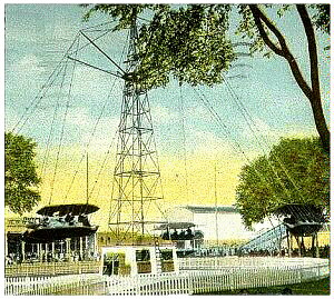 The park's Aerial Swings in action in this hand-tinted postcard. |
circa 1920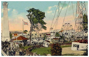 A later view of the same ride. Note in the background, the addition of a Ferris Wheel |
| This view shows the tree-lined grove in the center of the park. The attraction appears to be a dare-devil bicycle loop-the-loop setup. On the right are midway buildings. |
Entertainment
Circa mid 1910s 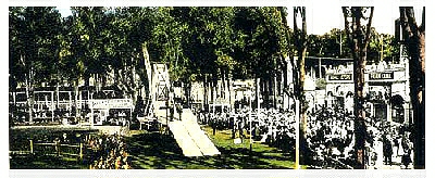
|
|
Bicycle Ramp circa 19-0s 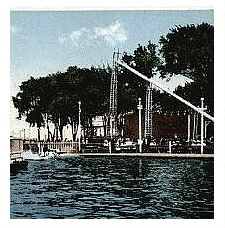
|
Here is a view from across the lagoon of what appears to be a higher bicycle ramp. It runs in the opposite direction to the one seen in the above photo. The Chutes ride is out of frame to the left. |
|
Trapeze artists entertain park patrons
on a summer day. At far right through
the trees may just be discerned the
Aerial Swings tower.
|
Acrobats
Circa mid 1910s 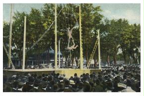
|
One item of note is that "Dare Devil Babcock" performed his Loop-the-Loop during the week of July 31st, 1916. This type of stunt is likely what is depicted in one or both of the photos before the "Trapeze" one above.
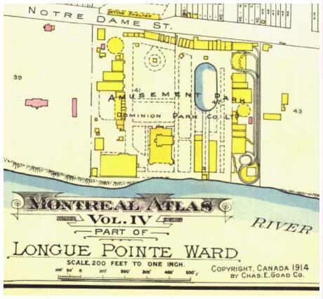
Goad Planner Map
1914
(Bibliothèque et Archives Nationales du Québec Map #174399_434)
This is a cropped map from the Charles Goad 1914 Montreal Atlas. The River is the St. Lawrence, with Rue Notre Dame Street at the top. Compare this with the pictorial image at the opening of this article.
Regarding only within the park's boundary: The coaster layout is visible at the right, with the central pond and Chutes run clearly seen right of center. At the upper left, the yellow circle with the dashed border represents the carousel, while the dashed, teardrop shape farther to its right represents The Aerial Swings. Other shapes can be compared to the photos throughout this article to discern what each represents, although some of the map shapes will be different due to changes made during nine seasons and also after the 1913 fire.
The
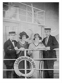
Photo StudioThe park had a photo studio where one might have personal pictures taken as souvenirs. Lynda McCormick of Beaconsfield, Quebec sent a photo (below left) of her grandfather and father (Damien & Lucien Terriault of Lachine, Quebec), taken in 1921. Her father, who had been born in 1905, would have been 15 or 16 years old at the time. The two are pictured on a ship mock-up with a deck railing in the foreground upon which is mounted a life preserver sporting the words "S.S. Dominion Park". The second and third photos were likely taken in different years and show more of the studio set and painted backdrop.
Note that no one is smiling. This is typically because film speeds were slow in those days so exposures were long. It was too hard to hold a realistic smile for the entire length of exposure.
|
Dominion Park Photo Studio 1921 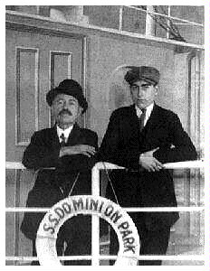
|
In this interior view of the studio,
are Damien & Lucien Terriaulta. Their
picture was taken on a photographic
set made to resemble a steam ship of
the era. Note the park's name on the
life preserver.
|
| For this photo, a group of four persons meant the photographer had to take a wider angle shot. The result is that we can see more of the `ship' set and life preserver. This flotation device appears to have a chunk missing from its bottom. |
 Dominion Park Photo Studio Mid 1920s |
|
Dominion Park Photo Studio Circa Late 1910s or Early 1920s 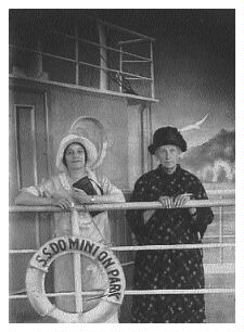
|
A third photo shows more of the
shoreline in the painted set behind
the subjects. Also visible is the
seagull hinted at in the previous
photo.
|
|
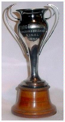
Nothing has come to light about the park's later years. 1929 could have been Dominion's last season. One clue is that the closing date for The "Dips" coaster is 1929. If the park did not reopen after that season, it likely was because it suffered the fate of many businesses after the stock market crash - it ceased to exist. On the other hand, perhaps the coaster was a concession and its concessionaire went bankrupt in the 1929 crash and was unable to open for 1930, nor to be able to locate a buyer. Having said that, the park continued in at least some fashion, as the 1935 dance contest trophy at the left attests. Additional references to the park closing give 1937 and 1938, but reports have not yet surfaced to be definitive regarding the exact date. |
|
Thanks to Christine Van Yperen of Montreal for sharing so many of her
photos, as seen in this article. The miniature train postcard scan is courtesy of Irene Kuziw of Winnipeg, Manitoba. A thankyou to Michel Gagnon of Montreal for suggesting the Goad map and sending a scan. A special thankyou to him for taking the time to send translations of French-language newspaper articles regarding the 1913 fire. Thanks to the Hennepin History Museum for blueprint access and to Greg Van Gompel of Savage, Minnesota for submitting photographs of the prints to the CEC. |
Return to the
Closed Canadian Parks Introduction
Return to the
Closed Canadian Parks Index